
Typhoon Nr. 10 台風10号 Krosa
- source : typhoon.yahoo.co.jp
- source : Japan Meteorological Agency
:::::::::::::::::::::::::::::::::::::::::::::::::::::::::::::::::::::::::::::::::::::::::::::::::::::
Typhoon Nr. 10 - August 06

台風10号が8月6日午後3時にマリアナ諸島で発生しました。
8月6日午後3時現在、マリアナ諸島にあって北西へ毎時15キロで進んでいます。発生時から強風域が広い大型の台風10号は、発達しながらゆっくり北上し、9日午後には強い勢力で小笠原近海に達する見込みです。
中心気圧 998hPa
Wednesday August 07 morning

August 08 morning

大型で強い台風10号は、
8日(木)正午現在、小笠原近海にあって、ほとんど停滞しています。中心気圧は965ヘクトパスカル、最大風速は40メートル、最大瞬間風速は55メートルとなっています。
この台風は今後、発達しながらゆっくり北上する見込みです。
9日(金)午前9時現在、
小笠原近海にあって、ほとんど停滞しています。中心気圧は950ヘクトパスカル、最大風速は45メートル、最大瞬間風速は60メートルとなっています。
強風域 (15m/s以上) 中心から600km
Still heading North, maybe toward Okayama, maybe toward Tokyo

10日(土)午前9時現在、小笠原近海にあって、北にゆっくり進んでいます。中心気圧は965ヘクトパスカル、中心付近の最大風速は35メートル、最大瞬間風速は50メートルとなっています。
この台風は今後も発達しながら、ゆっくりと北上する見込みです。
強風域 (15m/s以上) - 南側650km / 北側560km
.......................................................................
August 11 - Sunday

(日)午前6時現在、
小笠原近海にあって、ほとんど停滞しています。中心気圧は965ヘクトパスカル、中心付近の最大風速は35メートル、最大瞬間風速は50メートルとなっています。
この台風は13日にかけて日本の南海上を北西に進み、その後は進路を北よりに変えながら15日頃に西日本に接近し、上陸するおそれがあります。
また、西日本と東日本の太平洋側や南西諸島でも、12日午後からはうねりを伴った大しけとなる見込みです。
強風域 (15m/s以上) 南側 850km // 北側 650km
This is a HUGE one !
More than 1500 km in diameter!
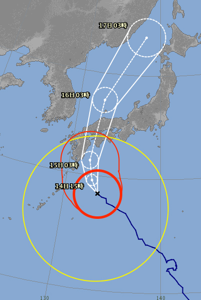
午後3時現在、
父島の南南西約460キロにあって、時速10キロで北西へ進んでいます。中心気圧は965ヘクトパスカル、中心付近の最大風速は35メートル、最大瞬間風速は50メートルとなっています。
この台風は13日にかけて日本の南海上を北西に進み、その後は進路を北よりに変えながら15日頃に西日本に接近し、上陸するおそれがあります。
また、西日本と東日本の太平洋側や南西諸島でも、12日午後からはうねりを伴った大しけとなる見込みです。
still moving very slowly 速さ 10km/h
強風域 (15m/s以上) 南側 950km // 北側 560km
.......................................................................
August 12 - Monday
12日(月)午前3時現在、
父島の南西約490キロにあって、時速15キロで西北西に進んでいます。中心気圧は965ヘクトパスカル、中心付近の最大風速は30メートル、最大瞬間風速は45メートルとなっています。
この台風は13日にかけて日本の南海上を北西に進み、その後は進路を北寄りに変えながら北上する見込みです。15日(木)頃に西日本に接近し、上陸するおそれがあります。
速さ 15km/h speed
暴風域 (25m/s以上) 中心から280km / at 6:00 中心から330km
強風域 (15m/s以上) 南側950km // 北側560km

12日(月)午後3時現在、
父島の西南西約500キロにあって、時速15キロで北西に進んでいます。中心気圧は965ヘクトパスカル、中心付近の最大風速は30メートル、最大瞬間風速は45メートルとなっています。
この台風は13日(火)にかけて日本の南海上を北西に進み、その後は進路を北寄りに変えながら北上する見込みです。15日(木)頃に西日本に接近し、上陸するおそれがあります。
大きさ 超大型 - size : extremely large !
強風域 (15m/s以上) 南側 1100km / 北側560km
Still growing in size !
- and at 18:00 - typhoon clouds - mapion

.......................................................................
August 13 - Tuesday
13日(火)午前3時現在、
日本の南にあって、時速15キロで北西に進んでいます。中心気圧は965ヘクトパスカル、中心付近の最大風速は30メートル、最大瞬間風速は45メートルとなっています。
この台風は14日から15日にかけて暴風域を伴い、強い勢力で西日本に接近し、上陸するおそれがあります。
13日は西日本と東日本の太平洋側や南西諸島では、うねりを伴った大しけとなり、高波に警戒が必要です。台風の接近に伴い14日から15日にかけては猛烈な風が吹き、猛烈なしけとなる所があるでしょう。暴風や高波に厳重な警戒をしてください。
速さ 15km/h - still very slow
The size has not changed a bit , . Huge !

- and at 06:00 - typhoon clouds - mapion

3日(火)午前9時現在
速さ 20km/h - picking up speed
- NHK news
Severe tropical storm Krosa is moving northwest over waters south of Japan. It could make landfall somewhere in the country by Thursday.
The Meteorological Agency warns that western and eastern Japan could see heavy rains even before the storm nears land.
The storm is expected to further strengthen as it comes close to western Japan on Wednesday and Thursday.
Strong winds are forecast along the Pacific coast of western and eastern Japan. Winds of up to 108 kilometers per hour are expected in southern Kyushu.
Over the 24-hour period to Wednesday morning,
300 millimeters of rain are forecast for the Tokai region, 200 millimeters for Kansai and 100 to 150 millimeters for Kyushu and Shikoku.
Over the 24 hours to Thursday morning,
400 to 600 millimeters of rain are expected in Shikoku, 300 to 500 millimeters in Kyushu and Kansai, and 300 to 400 millimeters in Tokai.
Weather officials say some areas could see total rainfall of more than 1,000 millimeters.
(Our Okayama Chugoku region is not mentioned ... )
- Rain forecast at 12:00

13日(火)正午現在、
強風域 (15m/s以上) 南側1100km / 北側 600km - growing !
13日(火)午後3時現在、
種子島の南東約490キロにあって、時速15キロで西北西に進んでいます。中心気圧は965ヘクトパスカル、中心付近の最大風速は30メートル、最大瞬間風速は40メートルとなっています。
この台風は14日から15日にかけて暴風域を伴い、強い勢力で西日本に接近し、上陸するおそれがあります。
速さ 15km/h - back to slow speed !
- Rain forecast at 16:00

longer than forecast at 12:00
.......................................................................
August 14 - Wednesday
大型の台風10号は、14日(水)午前3時現在、
種子島の南東約350キロにあって、時速15キロで西北西に進んでいます。中心気圧は965ヘクトパスカル、中心付近の最大風速は30メートル、最大瞬間風速は40メートルとなっています。
この台風は15日にかけて暴風域を伴い、強い勢力で西日本に接近し、上陸するおそれがあります。
また、15日にかけては、台風本体や周辺の発達した雨雲が流れ込み、西・東日本の太平洋側では、局地的に雷を伴い猛烈な雨の降る所があるでしょう。
大きさ 大型 - just Large, not extremely . ..
速さ 15km/h - still slow
暴風域 (25m/s以上)
強風域 (15m/s以上) 南側 850km 北側 600km
- rain forecast - - 降水量(mm)
0時 3時 6時 9時 12時 15時 18時 21時 -- at 6:00
02 02 03 14 12 30 67 52 - yahoo
0ミリ 1ミリ 1ミリ 2ミリ 3ミリ 7ミリ 7ミリ 9ミリ - mapion
01 02 03 07 09 29 87 78 - at 8:00
01 03 11 22 20 36 68 52 - at 15:00
0ミリ 0ミリ 0ミリ 1ミリ 3ミリ 7ミリ 10ミリ 8ミリ - mapion at 18:00
strong wind forecast for August 15
12メートル - 12 meter at 12:00
14日(水)午前6時現在、
種子島の南東約340キロにあって、西北西にゆっくり進んでいます。中心気圧は965ヘクトパスカル、中心付近の最大風速は30メートル、最大瞬間風速は40メートルとなっています。
この台風は15日にかけて暴風域を伴い、強い勢力で西日本に接近し、四国地方に上陸するおそれがあります。
速さ ゆっくり - moving VERY slow
暴風域 (25m/s以上) 中心から240km
強風域 (15m/s以上) 中心から 600km
- NHK news
The officials say the rain will intensify from Wednesday. They say some Pacific coastal areas of western and eastern Japan may have localized downpours of more than 80 millimeters per hour.
They say the heavy rain may continue even after the storm moves away, and overall precipitation could reach 1,000 millimeters in some areas.


- NHK news
Predicted rainfall for the 24 hours through Thursday morning are 500 millimeters in southern Kyushu, Shikoku and Tokai, and 400 in northern Kyushu and Kansai.
Expected rainfall for the 24 hours through Friday morning are 600 to 800 millimeters in Shikoku and Tokai, 400 to 600 in Kansai, and 200 to 300 northern Kyushu, Chugoku, Hokuriku and Kanto-Koshin.
Overall precipitation may exceed 1,000 millimeters in some areas.
- at 15:00

The first bouts of storm have rattled our roof !
速さ 15km/h speed
暴風域 (25m/s以上) 南東側260km / 北西側200km center strength
強風域 (15m/s以上) 南東側600km / 北西側520km

- at 17:00
It started raining.

and more rain to come !

速さ 20km/h - picking up speed
暴風域 (25m/s以上) 南東側 280km / 北西側170km
- NHK
Airlines in Japan will suspend at least 228 domestic flights on Thursday as severe tropical storm Krosa approaches the west of the country.
A Japanese railway operator says it will suspend services on most sections of its Shinkansen bullet train line in western Japan throughout Thursday due to an approaching severe tropical storm.
West Japan Railway, or JR West, says it will cancel Sanyo Shinkansen services between Shin-Osaka Station in Osaka Prefecture and Kokura Station in Fukuoka Prefecture for the whole day.
. . . this is a serious problem because of the O-Bon travel season !

.......................................................................
- - - - - August 15 - Thursday - - - - -

- rain forecast - - 降水量(mm)
0時 3時 6時 9時 12時 15時 18時 21時 -- at 6:00
00 06 08 17 22 28 43 22
0ミリ 1ミリ 2ミリ 4ミリ 10ミリ 10ミリ 5ミリ - mapion
00 02 03 13 19 16 17 19 -- at 9:00
風向 風速(m/s)wind strongest at 7 in the afternoon
15日(木)午前5時現在、
足摺岬の南南西約100キロにあって、時速20キロで北に進んでいます。中心気圧は975ヘクトパスカル、中心付近の最大風速は30メートル、最大瞬間風速は45メートルとなっています。
この台風は暴風域を伴ったまま北上し、15日昼前から昼過ぎにかけて四国地方を通過、または上陸し、その後、中国地方を縦断する見込みです。
速さ 20km/h moving
暴風域 (25m/s以上) 東側330km / 西側170km
強風域 (15m/s以上) 東側600km /西側500km


15日(木)午前7時現在、
暴風域 (25m/s以上) 東側330km // 西側60km
- NHK news at 10:45 -
Meteorological Agency officials estimate that Krosa was situated 40 kilometers south-southwest of Uwajima city in Ehime Prefecture at 10 a.m. on Thursday.
Rainfall for the 24 hours through Friday morning is expected to reach 800 millimeters in Shikoku, 500 in Tokai and Kinki.
679 domestic flights canceled for Thursday
The severe tropical storm is disrupting Shinkansen bullet train services, mostly in western Japan.
15日(木)午前11時現在、
愛媛県八幡浜市付近にあって、時速30キロで北に進んでいます。中心気圧は975ヘクトパスカル、中心付近の最大風速は30メートル、最大瞬間風速は45メートルとなっています。
速さ 30km/h moving faster
- At 12:00
We are now in the red strong wind circle of the typhoon.

15日(木)正午現在、
愛媛県八幡浜市付近にあって -- この台風は今後も北上し、15日夕方にかけて中国地方に上陸する見込みです。
- At 14:00

Making landfall near Hiroshima.
- at 15:00

The typhoon has lost its red circle of very strong wind.
15日(木)午後3時頃、
広島県呉市付近に上陸しました。
中心気圧 978hPa
速さ 30km/h moving faster
強風域 (15m/s以上) 東側600km // 西側500km
- the wind around my home has slowed down just a little bit.
Rain not so strong.
.......................................................................
August 16 - Friday

6日(金)午前3時現在、
島根県松江市の北約280キロにあって、時速35キロで北に進んでいます。中心気圧は980ヘクトパスカル、中心付近の最大風速は25メートル、最大瞬間風速は35メートルとなっています。
16日にかけて、西日本から東日本では太平洋側を中心に、雷を伴った非常に激しい雨が降り、大雨となるでしょう。
土砂災害や低い土地の浸水、河川の増水や氾濫に厳重に警戒し、暴風や高波、高潮に警戒して下さい。また、落雷や竜巻などの激しい突風にも注意が必要です。


We are still in the yellow circle of strong wind
so is most of Japan !
This is a HUGE typhoon after all!
.
- NHK news
Tropical storm Krosa has barreled through western Japan, leaving one person dead, 49 injured and one other missing .
the storm is moving north after bringing torrential rain to Hiroshima and Shimane prefectures.
Some areas have seen up to 800 millimeters of rainfall. More heavy downpours are expected for wide areas along the Pacific coast on Friday.
Airlines canceled over 800 domestic flights on Thursday. Another 48 flights were axed on Friday morning and flights to and from Tohoku and Hokkaido face disruptions depending on the course of the storm.
Bullet train services in western Japan are back to normal on Friday while they were either cancelled or reduced on Thursday. But railway companies say some regular trains will be cancelled to confirm the safety of the tracks.
16日(金)午前9時現在
速さ 35km/h
強風域 (15m/s以上) 南東側750km / 北西側460km
:::::::::::::::::::::::::::::::::::::::::::::::::::::::::::::::::::::::::::::::::::::::::::::::::::::
. Typhoon season 2019 - 台風情報 .
大垪和 。。。道の駅に戻る – Michi no Eki - BACK
:::::::::::::::::::::::::::::::::::::::::::::::::::::::::::::::::::::::::::::::::::::::::::::::::::::


No comments:
Post a Comment